Month:
November, 2008

Reader Don Hallstrom left the following comment this morning:
Hello Eric
I believe you are reviewing posts prior to them getting to your blog. I hope so as this is off subject, but wanted your opinion and wasn’t really sure how to contact you other than the blog. I certainly don’t want to clutter the blog up. If you could respond to the email listed, I would greatly appreciate it. I’ve been checking in with your blog weekly for about a year and also reviewing the archive. I’ve really enjoyed the information.
At one point you and fellow blogger Drew Wagenhoffer over at his blog have both commentted about White Mane Publishing and their products.
I’ve been collecting Civil War books for over 20 year and I’m in the process of getting the collection appraised and doing a little culling. I have a number of White Mane books and earlier in my collecting I wasn’t very picky. However, as time has gone by and I’ve found more resources of information, I’ve become a stricter collector. Below are the titles I have. I bought some because I liked the subject and others because there wasn’t anything written about the subject. There certainly are some duds in the list!
I recently came across a title I wasn’t aware of and wanted you opinion of this title and another I was looking at.
1. Hoosiers Honor The Iron Brigade’s 19th Indiana Regiment – Venner, William ( I have a history of same regiment by Dunn from Guild Press).
2. Stopping Pickett The History of the Philadelphia Brigade – Gottfried (Gottfried is coming to our next Rocky MTN Roundtable Sympossium)
Are there any White Mane Titles you would recommend? Always looking for good material
My White Mane Purchases:
INTO THE FIGHT, PICKETT’S CHARGE – PRIEST
VICTORY WITHOUT TRIUMPH – PRIEST
ANTIETAM SOLDIERS BATTLE – PRIEST
BEFORE ANTIETAM, SOUTH MOUNTAIN – PRIEST
NOWHERE TO RUN – PRIEST
RED DIAMOND REGIMENT – JORDAN
LAW’S ALABAMA BRIGADE – LAINE
THE STRUCK EAGLE, MICAH JENKINS – BALDWIN
PUT THE VERMONTERS AHEAD – PARSONS
THE SOUTH’S FINEST – TUCKER
WE SHALL MEET AGAIN – MCDONALD
THE LITTLE JEFF – HOPKINS
FROM SELMA TO APPOMATTOX – LABODA
27TH INDIANA INFANTRY – JONES
PICKETT – LONGACRE
DISTINCTION IN EVERY SERVICE BIO. OF GEN. CLINGMAN – BRAGGRegards and have a happy holiday season
Don Hallstrom
I answered Don privately. The gist of it was to reiterate something I’ve said more than once, which was that if I had to choose between having White Mane publish one of my books and never publishing another word again for the rest of my life, I would readily and easily choose never publishing another word again for the rest of my life. Poor production values, thin, cheap paper, no editing to speak of, crappy, cheap binding, no marketing to speak of, White Mane turned out a lot of really terrible books and a handful of good ones. Don’s list mentions a few of the better titles, such as the history of the Jeff Davis Legion and some of John Michael Priest’s stuff.
One of the best books that White Mane published was George Rummel’s Cavalry on the Roads to Gettysburg: Kilpatrick at Hanover and Hunterstown, which definitely deserved a better fate than White Mane.
Its demise was not lamented by me or by anyone who really knows anything about quality books. It’s an old cliche that even a blind squirrel will find an acorn every now and again, and the same was true about White Mane. Interspersed among the legion of terrible books that they published, there were a handful of good ones over the years, books that really deserved better publishers.
My view of the demise of White Mane is good riddance to bad garbage.
Scridb filterLike so many other millions of Americans, Susan and I will be hitting the road this afternoon, headed to my hometown of Reading, PA for Thanksgiving. It’s going to be a long and miserable drive, but hopefully, the joy of spending holidays with one’s loved ones makes the suffering worthwhile.
To each and every one of you who give part of your day to indulge my rantings, we wish you a joyous, happy, and healthy Thanksgiving. In spite of these very grim economic times, we still have plenty for which to be grateful, including the hope of a new beginning.
Personally, I am thankful for each of you for the time you spend here.
Have safe travels, enjoy the turkey and the football, and most of all, enjoy the time with your families.
Scridb filterFrom today’s issue of the Hanover Sun newspaper:
Spot for Lincoln statue sought
By ERIN JAMES
Evening Sun Reporter
Posted: 11/25/2008 08:36:06 AM ESTAnyone got room for a nine-foot-tall statue of Abraham Lincoln?
A Salt Lake City-based sculptor has offered his latest art project to Gettysburg Borough officials on the condition that they find a place for it. And the town’s Borough Council is open to suggestions from the public – though they’ve got a list of potential Lincoln locales already in the works.
At the top of the list are two locations – the Adams County Public Library and Alumni Park, both on Baltimore Street in the borough – that council members Susan Naugle and John Butterfield said they are most strongly considering.
Other potential locations include the Lincoln Train Station on Carlisle Street, the future site of an Adams County Transportation Authority transit center on Carlisle Street, the Gettysburg Presbyterian Church on Baltimore Street and a spot in front of a York Street business.
Lincoln Square was also discussed as a possibility but will likely be dismissed because another Lincoln statue already resides there.
However, Naugle and Butterfield said they would prefer the Baltimore Street locations because of their proximity to other tourist attractions. If those plans move forward, it will be up to the library’s board and the Gettysburg Area School District – which owns Alumni Park – whether the statue could be placed on their properties.
The search for Lincoln locales is not over, however. No decision has been made by the full Borough Council, and Butterfield said officials are open to suggestions from the public about where Stanley Watts’ statue of Lincoln would best serve Gettysburg.
Watts has already begun work on the statue, for which he is using actual casts of Lincoln’s face and hands. The statue will portray Lincoln giving his famous Gettysburg Address, and a copy of the speech will be held in his hand and legible to viewers, Watts has said.
Watts had wanted the statue to be installed before Lincoln’s 200th birthday in February, but council members said that is unlikely to happen. The sculptor’s proposal to Gettysburg officials was made only recently.
Anyone with suggestions on where to place the statue should call borough Secretary Sara Stull at (717) 334-1160, extension 221.
Contact Erin James at ejames@eveningsun.com.
It would appear that the supply of statues of Old Abe outstrips the demand, at least in Gettysburg. Who’da thunk it?
Scridb filterJ. D. Petruzzi has an interesting but sad post on his blog today regarding the destruction of the stone wall that was the focus of some fairly bitter fighting between troopers of Brig. Gen. David M. Gregg’s Second Cavalry Division and the Stonewall Brigade of Lt. Gen. Richard S. Ewell’s Second Corps for several hours late in the afternoon of July 2, 1863. JD also points out that the landowners have re-graded the ground to the east of where the wall stood and have changed the historic lay of the land.
That stone wall became the linchpin to the position, and, at one point, there was literally a race between troopers of the 10th New York and 3rd Pennsylvania Cavalry regiments and soldiers of the 2nd Virginia Infantry as to who would seize and hold the wall. At the time, the wall was waist-high and served as a very strong natural breastwork that sheltered whichever side held it. The dismounted Federal horse soldiers won the race and held the position for the rest of the fight.
The wall itself began at the intersection of the Hanover Road and Hoffman Road, which runs perpendicular to the Hanover Road, and extended north for fifty yards or so. Due to erosion and settling dirt and plant growth, the wall was hard to find, but it was still there. If you knew where it was, it was easy to find. I used to love standing on it to interpret the fighting on Brinkerhoff’s Ridge. It was very cool knowing that I was standing on the spot that was the focal point of the fighting I was describing at that very moment.
Old friend Stan O’Donnell, who has a place right next to East Cavalry Field, had let me know that the owner of the property had cleaned up a lot of brush and had cut down scrub trees that blocked the view from Brinkerhoff’s Ridge to the battlefield at East Cavalry Field. Without that stuff in the way, you can clearly see the Michigan Cavalry Brigade monument and the Cavalry Shaft from Brinkerhoff’s Ridge, which makes the interpretation of the Brinkerhoff’s Ridge much easier. That part is good news.
The senseless and needless destruction of that historic stone wall and the regrading of the ground to the east of it, on the other hand, is not good news at all.
As I said in the comment that I left on JD’s blog, this sort of thing is tragic, but it’s probably also unavoidable. The march of progress goes on, no matter what. So long as that wall was in private hands, the threat of this sort of thing was always there. Thus, when JD called me to tell me the bad news, I was bummed, but I cannot honestly say that I was terribly surprised.
It’s tragic, but there are so many important sites associated with the Battle of Gettysburg that lay outside the park boundary that this sort of thing is, unfortunately, inevitable. Given my personal connection with this piece of the battlefield, I am especially disappointed that this happened and that the lay of the land and the stone wall will never be the same again.
Scridb filterPlease forgive this rant, which has absolutely nothing to do with the Civil War.
Today, I suffered through my third straight week of watching some of the most pathetic offensive football since the Roman Gabriel days of my childhood in the early 1970’s. The Eagles’ offense did not score a single point today against the Baltimore Ravens; their only score was a 100-yard kickoff return in a very ugly 36-7 loss. This after a 13-13 tie with the 1-8 Cincinnati Bengals, and a 36-31 loss to the Giants the week before in a game that the Birds should have won.
Donovan McNabb has thrown 6 interceptions in his last game and a half, and he got yanked at halftime today after throwing 2 and coughing up a fumble in the first half alone. However, I don’t think it’s all his fault.
It is time for the Andy Reid era to end in Philadelphia. He and his pathetic excuse for an “offensive coordinator”, Marty Morninhweg, both need to go. It’s painfully clear from the last two weeks that the opposing defenses are so familiar with their lame play calling that they’re predicting most calls and playing them as if they know what’s coming. Well, as one of the Cincinnati defensive backs said after last week’s game, they DO know what’s coming. They’re predicting the incredibly unimaginative play calls.
Given that, it shouldn’t come as any big surprise that McNabb has thrown six interceptions in the last game and a half, or that young Kevin Kolb threw two, including one that was returned for an NFL-record 108 yards and a touchdown.
I realize that Reid is the winningest coach in the history of the franchise, but it’s also clear that things are moving in the wrong direction, that this team is getting worse and worse with each passing week, and all of that falls squarely on the shoulders of the coaching staff, which cannot come up with a decent game plan anymore.
Reid and Morninhweg need to go. The only question is whether owner Jeffrey Lurie and team president Joe Banner have the stomach to do what needs to be done. I can only hope so.
I feel better now. I will get back to the normal business of this blog tomorrow. For now, I again apologize for this rant.
Scridb filterAn active duty Army officer named Doug Davids left an interesting comment on my very early post on Tom Carhart’s crappy book. The comment left was good enough that I decided to pull it forward and feature in an actual blog post. Here’s the comment that Doug left earlier today:
Eric,
Sorry for the late reply. I’m at a busy time. Also, I’ll heed the warning on the language. I forget that civilians are not used to the sometimes overly blunt and colorful language we use in the military. I’ll tone it down. BTW: I appreciate you having a web site that opens up dialogue such as this discussion. I think it makes for great debate of an obviously very controversial topic.I must say I’m first very interested in who at the time said that Stuart was on the flank? That is a mystery to me, and I’d like to see how he stated it and in what context. Was it the report of Stuart’s aide…McClellan?
If I were to develop a MCOO (Modified Combined Obstacle Overlay) and a mobility overlay, Stuart would not end up on a flank, but clearly behind my lines. First, I recommend to try not to think of a units location based on latitude/longitude (as I know he is pretty much straight east of Ewell), but think of “effects†(a term we commonly use in our current combat zones). If Stuart’s intent was to somehow have an effect on the flank, he is much too far east to be doing a screening operation (i.e. on the defense), and if he is on the offense to effect the flank, he is pretty far away. I even had one of my armor NCOs state that if Stuart was trying to affect the Meade’s flank, he appears to be lost. I’ll talk McClellan’s comments later on.
If I were to make the overlays mentioned above, I would probably draw my lines to show anything that could possibly have an effect on my rear as anything east of Rock Creek and White Run Creek (I’m looking at a map which shows the battlefield din 1863), as I have Union cavalry screening just northwest of the White Creek area. On a modern map, Highway 15 is well behind my lines, and Stuart is well east of that. If I were the Operations Officer of an army, and I told my commander that Stuart was not in my rear, but on the flank, and he then saw Stuart’s position, I’d be on a quick airplane home with a recommendation on my officer evaluation report saying “do not promote†(as a minimum). From that position, Stuart is not in a good position to roll my flank, but he can have a devastating effect on my rear operations, regardless of his being about a mile or two north of my exact center rear. His position would be frightful in regards to what he could do to my rear area. If Carhart’s map is correct, all Stuart needs to do is take the Bonaughton and Baltimore roads, and my army will be experiencing a very significant emotional event in the worst way in a very short time. Stuart would not be in a good position to role my flank because he would run into the cavalry screening my flank. But he is in a great position to wreak havoc on my rear.
I doubt the theory some have used that Stuart was going to just harass the lines of communication (LOCs). Attacking LOCs can have varying effects depending on how far to my rear they are attacked. However, there is nothing Stuart can do to my LOCs which could affect my ability to hold off Picket in an attack which is about to take place. Also, rear areas in armies during those days were not like rear armies of today which practically have cities of headquarters and logistics behind them. Meade was up near the front lines, and any weapons and munitions which would be used in the attack were either near the line, or too late in coming to have an effect on the battle. Had Stuart attacked any logistical wagons along the road 12-24 hours earlier, it might have had an impact. But Lee was already out numbered in the battle. Therefore, the principle of war “Mass†and “Economy of Force†were of utmost importance to Lee, just as they had been in all Lee’s previously battles. He could not attack the full Union line, he had too few forces, but he had to use “economy of force†and concentrate his “mass†at the key location (something he was remarkably effective at during the 7 Days Battle). If Lee was sending the large groups of troops away from the battlefield to attack LOCs, I would need to take Lee of the list of great tacticians, and put him down with the three Bs (Burnside, Butler, and Banks). Napoleon’s Les Manoeuvre Sur Les Derrieres (or “Strategic Envelopment†as David Chandler translates it) had been an effective technique Lee had employed earlier, and with Stuart’s previously knowledge of the enemy rear area from his earlier venture, using the Les Manoeuvre Sur Les Derrieres was a very good idea on Lee’s part.
As far as an historical sense, I do know that Stuart’s aide, H.B. McClellan stated that “At about noon Stuart, with Jenkins’ and Chambliss’ brigades, moved out on the York turnpike, to take position on the left of the Confederate line of battle.†It’s an interesting comment and I wonder if that is the one you are refereeing to. The route does take Stuart to the Northeast, and then his move south obviously puts him in geographically east of Ewell, but I would never call Stuart on the “Line of battleâ€. In 1863 warfare, Stuart would need to be almost touching to be on the “line of battle.†In modern warfare I could see the term used, but not in 1863. If that was truly Stuart’s intent to be on the line of battle, then I think my armor NCO is correct in stating that Stuart “was lost.†However, I cannot image Stuart moving several miles up the York Road and thinking he was still on the “line of battle.†He is anything but. If that is McClellan’s true intent, he is either mistaken, or intentionally trying to cover things up. I don’t know a military mind today who would call Stuart “on the line of battle†when he met the Union cavalry.
McClellan also states that “Stuart’s object was to gain position where he would protect the left of Ewell’s corps, and would also be able to observe the enemy’s rear and attack it in case the Confederate assault on the Federal lines were successful.†“Protect the left of Ewell’s corps? !!!!“ This leaves me seriously in question of McClellan’s motives about writing this. A proper screening operation to protect Ewell’s flank and rear would have been to have positioned his troops generally along creek that goes from behinds Ewell’s lines (Stuart would have needed to connect to the east flank of Ewell, of course), and generally hold the line along that creek as it goes between Benner’s and Wolf’s Hill (I don’t see a name on the creek on the old 1863 map I am looking at). Whether Stuart screened along the creek or on the hill would depend on the terrain on the ground, but based on a map recon, I’d initially look at putting my cavalry along the northwest side of the creek, and position my artillery on Benner’s Hill (vegetation and visibility from Benner’s Hill would obviously effect my decision). I would then ensure that I had proper surveillance on both Hanover and York Pike roads.
But as it was, Ewell’s rear and flank were very much vulnerable to Gregg’s cavalry had Meade and the Army of the Potomac had any sense of offensive operations in mind. Ewell’s rear was so exposed that I’m surprise that Gregg didn’t request an attack. There was nothing stopping it. Again, if McClellan really calls Stuarts position near the Low Dutch Road as ‘protecting Ewell’s corps,’ I need to put both Stuart and Lee on the list of the three Bs. Most offensive-minded commanders would dream of such an enemy “flank protection†position. I have great difficulty believing that McClellan really thought he could be taken seriously by professional military officers in saying that the two mile gap between Stuart and Ewell was ‘protecting Ewell.’ The position of the cavalry battle field leaves both the Hanover and York Pike roads complete exposed. Stuart is not protecting the Confederate rear!!! Perhaps had McClellan known the battle would be studied so much, he might have found a different excuse. Not to be rude, but I question McClellan’s sanity with the comment. No military mind would ever call Stuart’s position “flank protection“ or “rear protection†of any confederate force that day.
The final point would come to “hearsay, I suppose. As Fitzhugh Lee wrote: “The position held by my cavalry at Gettysburg on the morning of the 3d was held by them at dark. They never left it except to go to the front in a charge. Such a condition of things could not have existed had other portions of the line been abandoned.â€
That seems to indicate that Stuart stayed on the defensive the whole time. Yet, as Carhart quotes William Brooke-Rawle of the 3rd Penn, “In close columns of squadrons, advancing as if in review, with sabers drawn and glistening like silver in the bright sunlight, the spectacle called forth a murmur of admiration. It was, indeed, a memorable one.†There does seem to be room for Carhart’s comments that 4,000 confederates were on the move. Being so close to Meade’s rear, it would be a mystery of all times if Stuart had not made an attempt to strike Meade in the rear.
I think to sum it up I really have to question McClellan’s motives in why he said Stuart was in a position to protect Ewell. If the man were here today and told me that, I’d have no trouble telling him he were either completely ignorant or stupid, or a very bad liar. Stuart was in NO position to protect any part of the Confederate army, but he is in a dandy position to attack Meade’s rear!
V/R Doug
I appreciate the input and the dialogue.
The answer, of course, comes at least in part from Stuart’s own report. Here’s what Stuart said in his own report:
During this day’s operations, I held such a position as not only to render Ewell’s left entirely secure, where the firing of my command, mistaken for that of the enemy, caused some apprehension, but commanded a view of the routes leading to the enemy’s rear. Had the enemy’s main body been dislodged, as was confidently hoped and expected, I was in precisely the right position to discover it and improve the opportunity. I watched keenly and anxiously the indications in his rear for that purpose, while in the attack which I intended (which was forestalled by our troops being exposed to view), his cavalry would have separated from the main body, and gave promise of solid results and advantages.
Stuart does not say anything about having been ordered to launch an attack that was coordinated with the Pickett-Pettigrew-Trimble Charge. Rather, it’s quite clear that what he had in mind was to exploit an opportunity if it presented itself. I have no reason to believe that Stuart’s intentions were anything but what precisely what he said in his report.
His report is entirely consistent with Robert E. Lee’s words. Here’s what Lee said in his report:
The ranks of the cavalry were much reduced by its long and arduous march, repeated conflicts, and insufficient supplies of food and forage, but the day after its arrival at Gettysburg, it engaged the enemy’s cavalry with unabated spirit, and effectually protected our left.
NOWHERE does Lee say anything about Stuart’s operations having been intended to be coordinated with the infantry assault. His report states clearly that Stuart’s operations “effectually protected our left.” In other words, Stuart operated on the flank, just as he reported that his mission was intended to be.
It seems to me that if the intention had been to coordinate something with the infantry assault, surely either Lee or Stuart, or more likely both, would have said something about it. Neither did. I think that we’re entitled to accept their reports at their face value. While I very much appreciate Doug’s analysis, the historical evidence simply doesn’t support the conclusion.
Doug, thanks for writing, and please feel free to continue the discussion in the comments to this post.
Scridb filterThis excellent article from today’s issue of The Washington Post does a great job of explaining why I support the efforts of the Civil War Preservation Trust:
McMansionizing History: Can anyone save some of the Civil War’s most important battlefields?
By John A. Farrell
Sunday, November 16, 2008; Page W14In 1964, Michael Shaara, a frustrated writer of little-known fiction, took his wife and children on a road trip to the World’s Fair in New York. On their way home, they stopped at Gettysburg National Military Park, where a fine statue of Robert E. Lee guards the western reach of the famous battlefield.
The statue marks the area where, on July 3, 1863, Confederate Gen. George Pickett led some 13,000 men out from the shelter of the woods and up the long slope of Cemetery Ridge. Shaara and his 12-year-old son, Jeff, followed the path of Pickett’s men, across undulating ground and a fence at Emmitsburg Road. As they climbed the ridge, Michael Shaara told stories to his son. He recounted how Pennsylvanians had done what Lee did not think they’d do that day: They’d fought and died in defense of their state’s soil. He spoke of Confederate Gen. Lewis Armistead and Union Gen. Winfield Scott Hancock, great friends before the war, and how they lay bleeding, yards apart, not knowing the other was near. And when the Shaaras got to the small stone monument that marks the dirt where Armistead was mortally wounded, the boy was stunned to see his father weeping.
“What happened to my father, walking the ground at Gettysburg, changed his life,” Jeff Shaara remembers. “He became obsessed with telling that story.”
It took Michael Shaara seven years to complete “The Killer Angels,” which won the Pulitzer Prize for fiction in 1975, but not a wide audience. It was only in the wake of Ken Burns’s wildly popular 1990 PBS documentary series, “The Civil War,” that a faithful adaptation of Shaara’s book was filmed, propelling “The Killer Angels” to the top of the bestseller lists and establishing a family franchise. Michael Shaara, who died in 1988, never knew the success that Jeff has had with a series of novels that, in the style of his father, revisit the Civil War, the American Revolution and other storied clashes.
“It is a testament to the power of that ground,” Shaara says, remembering when he climbed Cemetery Ridge with his dad. “There is no substitute for coming out by the Lee statue, looking out across that mile of open ground and then walking it yourself. And realizing it is not that Hollywood stuff where guys charge, sort of screaming and yelling and lickety-split. No. They walked. One step at a time.”
Last summer, Shaara was asked to join the board of trustees of the Civil War Preservation Trust, whose calling is to save battlegrounds from bulldozers as sprawl creeps beyond the suburbs of Washington, Richmond and other cities with historic land nearby. The trust was formed in 1999, when the two small and troubled private groups merged and chose a onetime Maryland politico — Jim Lighthizer — to serve as president.
Lighthizer has built the trust into an effective organization that is part conservation fund, part lobbying shop, part political pit bull. He is not afraid to take the tools of modern politics — polling, direct mail, media — into battle with developers, and defeat them.
When the trust asked for Shaara’s help, “I listened long and hard,” the author says, “because this is a huge time commitment.” In the end, Lighthizer won him over. “He is the energy behind this.”
Which is noteworthy, because, when I ask Lighthizer what triggered his love for Civil War battlefields, he goes back to a day in 1983 when he asked a friend to recommend a book to take on vacation. Lighthizer was skeptical of his pal’s suggestion. “I don’t read novels. I read history,” he says. But the friend persevered, and in Nags Head, N.C., that summer, Lighthizer read “The Killer Angels.”
“It lit something that can best be defined as between a passion and an obsession,” he says.
The ground had inspired a story; the story a man, to save the ground.
“When I took the job… did I say we were going to start a political organization? No,” Lighthizer says. “But as the facts presented themselves, I recognized if we don’t get political, we are not going to be in business.”
He and I are driving down Interstate 95, heading toward Fredericksburg, Va., the small town on the Rappahannock River where, along a 10-mile arc, the Union and Confederate armies fought four legendary battles — Fredericksburg, Chancellorsville, the Wilderness and Spotsylvania Court House — from December 1862 through May 1864. Lighthizer is behind the wheel of an SUV: a pale-skinned, freckled man of medium height and build, with thinning reddish hair, expressive features and a sometimes goofy grin. The singular feature of his personality, a sly candor, won him the affection of the Maryland press corps during his eight years as Anne Arundel’s county executive and four years as transportation secretary under then-Gov. William Donald Schaefer.
He is a Democrat who delights in political incorrectness. He recalls — jokingly, I believe — that when one deal to protect a battlefield was hung up over the fate of the feral cats that inhabited the property, he toyed with the notion of delivering a few feline corpses, like the horse’s head in “The Godfather,” to the animal-loving landowner’s doorstep.
Lighthizer’s political acumen and deal-making skills have been put to the test trying to save the “hallowed ground” where more than 600,000 Americans lost their lives.
For a century after the Civil War, there was little cause to fret about its battlegrounds. In recent decades, that has changed. Entire battlefields have been lost to sprawl in Franklin, Tenn., and Atlanta. From the red clay around Richmond, developments with names such as Stonewall Estates have sprouted where Lee stopped the Union drive to capture the Confederate capital in 1862. Even the historic vistas at Antietam and Gettysburg have been put at risk, as the tendrils of exurban Washington creep into Western Maryland and southern Pennsylvania. In 1997, the federal government’s Civil War Sites Advisory Commission published an updated survey of 384 “principal” battlegrounds and warned: “This nation’s Civil War heritage is in grave danger. It is disappearing under buildings, parking lots, and highways. We may lose fully two-thirds of the principal battlefields.”
“I will give you an example,” Lighthizer says. “You know about Pickett’s Charge? It was a charge by 13,000 men, more or less, across a mile of open ground, supported by artillery, attacking a wall. What do you know about the Battle of Franklin? Well, it was an attack by 25,000 men — twice the number — over two miles of open ground, with no artillery support against a heavily fortified line, with significantly more casualties.
“And you know why most people haven’t heard about Franklin? Because they paved it over.”
The route we travel down I-95 offers compelling proof. For years, it was a lightly populated stretch of pine woods, creeks and rivers. Now, with its housing developments, malls and outlet stores, the land is being consumed at a rapid pace. Of the 100 fastest-growing counties in America, according to the U.S. Census Bureau, six are in Virginia, including Prince William, Stafford and Spotsylvania counties along the I-95 corridor. The boom has generated a backlash. Development-friendly county officials are being pressured by new residents, who want additional open space, fewer traffic jams and better planning.
Under Lighthizer, the trust has found ways to tap that slow-growth sentiment, which is ironic, given that Lighthizer presided over a period of rapid development as a county executive in the 1980s and as transportation secretary in the 1990s. Back then, contributions from developers fueled his political campaigns. In Anne Arundel, he concedes, “we issued 3,000 building permits a year, in some years.”
Yet, in a way, this makes Lighthizer a cunning soldier in the war he’s now waging against development. When he arrived at the trust, he recognized that his group could not outbid developers, who were inflating the value of land from about $2,000 an acre to as much as $40,000 an acre. “They would price us out of existence,” he says. “But the land-use process at the local level is often very political. I knew how to stop rezoning.” He had seen it done by determined residents who had sometimes thwarted projects he’d supported. “You can aggressively, as we have done, start grass-roots efforts to put the pressure on local officials.
“If we can compromise, we will do it — and have done it,” Lighthizer says. “But if we engage [developers] in battle, we want to make the battle so nasty and so brutal that even if we lose, they won’t ever want to cross our path again.
“Like somebody said after the Chancellorsville fight: Now all we have to do is bark.”
“This is the Zoan ridge,” says Robert Krick, who served as the National Park Service’s chief historian for some of Virginia’s most important battlefields before retiring several years ago. “It is the highest ground from here, eastward, to somewhere in France. Wonderful high ground. And just in front of you is where — when Joe Hooker did not have the nerve to come out of the Wilderness and take this dominating high ground — Stonewall Jackson bared his teeth, and Hooker collapsed upon himself.”
After Lighthizer and I pick up Krick up at the park’s headquarters, the three of us stand at the point where the sprawling housing developments and strip malls of greater Fredericksburg rub up against Chancellorsville Battlefield.
In the spring of 1863, swaggering Union Gen. Joe Hooker launched an ambitious assault on the Confederates. He sent part of his army across the Rappahannock just south of Fredericksburg. A second wing of the Union forces swung north and west, crossed the river, came down through the scrub woods known locally as the Wilderness and arrived behind the unsuspecting and outnumbered Rebels, halting that night at a 70-acre clearing at the small country crossroads called Chancellorsville. Hooker was jubilant. “Our enemy must either ingloriously fly, or come out from behind his defenses and give us battle on our own ground, where certain destruction awaits him,” he told his troops.
Lee responded by dividing his army and attacking Hooker on his own ground, as the Union general had predicted. On the morning of May 1, the armies clashed at the Zoan ridge, where, after a spirited battle, the Union general inexplicably ordered his men back into the Wilderness. Recognizing a psychological advantage, Lee divided his army again and sent Stonewall Jackson on a sweeping march around Hooker’s right flank, which ended in a surprise Confederate assault at dusk. The shock of the attack sent the Union forces reeling back to the river, though it cost Jackson his life — he was shot by his own troops in the chaos and gloom. The fighting at the Zoan ridge was the opening act in what historian Shelby Foote called “in terms of glory the greatest” of all Confederate victories.
“The fighting through here was not Armageddon but it was very significant because it pushed Hooker back,” Krick says. “And all of this land would be paved or covered with houses today, but Jim Lighthizer saved it.”
Lighthizer came to the preservation movement as a sportsman. He is a lifelong hunter, an Ohio boy who put himself through Georgetown University law school by selling typewriters for IBM. Inspired by John F. Kennedy, Lighthizer ventured into Democratic politics and won a seat in the Maryland House of Delegates in 1978. He was elected Anne Arundel County executive in 1982 and inherited a budget seeping red ink. He capped wages for Anne Arundel’s teachers and other public employees and encouraged development to grow the county’s tax base. By the end of his first term, he was able to cut property taxes and introduce a “smart growth” plan that satisfied the public yearning for containing sprawl. It had the added benefit, he says with a smile, of pressuring developers to donate to his campaign. He faced no real opposition for reelection.
Anne Arundel County is famed for its Colonial capital, Annapolis, and for hundreds of miles of shoreline on the Chesapeake Bay and its tributaries. Historic preservation, environmental protection and “quality of life” are huge issues there. Awash in revenue, Lighthizer let the conservationist in him blossom in his second term. He spent millions of dollars buying parkland on the rivers and bay. A lasting legacy of his tenure as county executive is the $17 million Quiet Waters riverfront park, near Annapolis, on 340 acres that he snatched from developers.
Lighthizer had a reputation for cockiness, fueled by the embarrassing disclosure that, as his second term ended, he had spent more than $100,000 of public funds on a glossy, 96-page, self-aggrandizing booklet titled “The Lighthizer Years.” Nevertheless, when he left in 1990, limited by law to only two consecutive terms, he was viewed as a potential candidate for higher office.
As state transportation secretary, he presided over the arrival of Southwest Airlines at Baltimore-Washington International Marshall Airport, a development that tripled flights and transformed the airport into a big-league operation. He won praise from conservationists for exploiting a clause in the massive 1991 federal transportation bill and using highway “enhancement” monies for battlefield preservation. At Antietam and other battlefields, the state spent more than $16 million to acquire land and conservation easements. The money, coupled with other open-space efforts, left Antietam, site of the war’s single bloodiest day of fighting, one of the nation’s best-preserved battlegrounds.
Then came a time of personal and professional ordeal. After Lighthizer became transportation secretary, state and federal investigators began scrutinizing several land deals that had been sanctioned by his administration during his time as county executive. Though no charges were filed, the investigations were an embarrassment.
They were followed by something far worse. In February 1993, a state trooper found Lighthizer’s son Robert, named in honor of Robert F. Kennedy, dead in a state park. The 23-year-old Army veteran, and former all-county lacrosse player, committed suicide. His son’s death “took a tremendous amount out of me,” Lighthizer says. “I went, in the course of a year, from thinking of running for governor to getting out of the business. I just decided I didn’t want to do this anymore.”
Instead Lighthizer went to work as a lobbyist in Annapolis, representing Southwest Airlines and other clients for the Baltimore law firm Miles & Stockbridge. He quickly came to detest his new duties. “If you want a lesson in humility, go from being county executive and transportation secretary to chasing state legislators up and down the hall,” he says. “I hated to go to work. I was making more money than I ever made in my life, and I was less happy, professionally, than ever. And in the end, I didn’t care if they got a comma in the tax bill.”
Lighthizer seemed on course to become just one more Maryland political hack. It was his obsession with the Civil War that rescued him from that fate.
Starting in 1890,Congress authorized the creation of the first four national military parks — at Chickamauga, Shiloh, Gettysburg and Vicksburg. But, over time, even major battlefields suffered from chronic federal budget shortfalls. At Fredericksburg, for example, the northernmost stretch was overrun by housing; the southern sector by an industrial park and a General Motors factory; and what’s known as the Slaughter Pen Farm, at the center of the battleground, was zoned for commercial or industrial development.
Over the years, the federal bureaucracies “lost deals because they couldn’t get appropriations, and they lost deals because they moved so goddamn slow when they had the money,” Lighthizer says. “And a lot of the important battlefield land is outside the Park Service boundaries, because the boundaries are arbitrary. They are political.”
Slaughter Pen Farm is outside the boundaries. “Some farmer went to his congressman 50 years ago and said: ‘Screw you. Don’t put me in that battlefield. I don’t want to be in it,’ ” Lighthizer says. “And so it’s not.”
At Chancellorsville, the federal government owns all but 1,703 acres of the 7,517-acre “core area” of the battleground, “where the heaviest fighting took place,” says Russ Smith, the Park Service superintendent there. The greater, federally recognized “study area,” which includes land on which the armies maneuvered or set up camps and field hospitals, is 21,874 acres. The threat of development led to the founding of aggressive local groups in Gettysburg, Northern Virginia and other locales, as well as two national organizations — the Civil War Trust and the Association for the Preservation of Civil War Sites — to buy land. But their efforts were unfocused, and by the end of the 1990s, the preservation association was $7 million in debt. Lighthizer was on the board of the Civil War Trust when the two groups merged in 1999, and the new trustees asked him to serve as president. There were 24 employees at the trust when Lighthizer took office; only four remained after six months. The rest were fired or left on their own. To replace them, Lighthizer tapped a community of battlefield buffs to find young professionals who had experience running political campaigns, congressional offices or commercial real estate operations. With the help of well-connected trustees and donors, he put his lobbying skills to work in Congress and state legislatures and retired the $7 million debt.
“We never ask for outright grants. Everything, we match,” he says. “I was in government. I know that when people come in with their hand out, you want them to have some skin in the game. So I say: ‘Lookit. You give me a million, and I will make it two. And, by the way, I will give the land back to you, if you want it.’ It’s a good argument.”
Membership in the trust tripled. A new direct-mail program brought in millions of dollars. And more than 20,000 acres of land at storied places — Manassas, Fredericksburg, Shiloh, Gettysburg, Harpers Ferry, Antietam, Brandy Station, Malvern Hill — were bought outright or saved via conservation easements, which give landowners tax breaks for giving up the right to develop their properties.
Buying property from willing sellers was one thing. It was quite another to rescue land that had already been purchased by developers and designated for high-density residential and commercial growth. Lighthizer accepted that challenge at what became known as “the second battle of Chancellorsville.”
The first volleys were fired in 2002 after the Spotsylvania County Board of Supervisors voted to move the Zoan ridge property out of the county’s rural preserve and into its “primary settlement” district, thus opening the land for high-density development. In June, the Dogwood Development Group of Reston announced plans to build a town center on the spot, with more than 2,000 homes and 2.4 million square feet of commercial space. In November, the county planning commission approved the developer’s plan, dismissing the growth-related concerns of a large crowd of local residents who waited hours to testify. When Lighthizer tried to negotiate, the developer and the county government ignored him. Furious, he decided to fight the development by orchestrating public pressure and, if necessary, defeating the pro-development supervisors at the polls.
“Nothing we have ever done compares to this. Nothing,” Lighthizer wrote in a fundraising letter to his membership. “If you never give another dollar to help save another battlefield, I need you to help with this one. If we succeed not only will we save 140 essential acres at Chancellorsville, but in years to come, savvy developers will think twice about going head to head against us they’ll go build their strip malls somewhere else.”
The Coalition to Save Chancellorsville Battlefield was formed that summer. A pollster was hired to gauge community sentiment, and the results (showing that almost two-thirds of nearby residents opposed the development) were released to local news outlets. The coalition held news conferences and lured national media such as Washington Post columnist George Will and National Public Radio to report on the controversy. Volunteers conducted a petition drive, collecting 27,000 signatures from residents who opposed the development. They canvassed neighborhoods, distributed leaflets and yard signs, held candlelight vigils and attended public hearings. A Web site kept the anti-growth forces alert to fresh developments, and served as a community rallying point. There were radio ads and a direct-mail appeal.
Dogwood fought back with telemarketing and mailings of its own, dismissing the 1863 action on the Zoan ridge as a “skirmish” that could suitably be honored with a small “memorial park.”
“These outsiders think they know what’s best for you,” the developers’ political action committee said in a mailing to area residents. “They came from places like New York, New Jersey, Ohio and Pennsylvania. They’ve never been stuck in our traffic, worried about improving our schools, or had to travel out of the county to spend their money to shop.”
But the coalition’s efforts had transformed the political climate. That fall, the voters filled a vacant seat on the Board of Supervisors with a candidate endorsed by the slow-growth forces: Robert Hagan got 64 percent of the vote. In January, when they had to fill a vacancy on the board, the supervisors selected Hap Connors, one of the coalition leaders. Then, in March 2003, as hundreds of county residents sat watching, the increasingly nervous supervisors voted 6 to 0 to reject the Dogwood proposal. The revolution peaked on Election Day 2003, when five pro-preservation candidates were elected supervisors, giving the movement control of the board.
The trust found a local homebuilder, Tricord Inc., that was willing to deal. In 2005, according to the trust, Tricord purchased 227 acres of the Dogwood property for more than $12 million and immediately transferred the 140 most important acres to Lighthizer’s group for $3 million. In return, the coalition forces and the supervisors agreed to let the builder put higher-density housing on the remaining 87 acres. In late 2006, the supervisors unanimously approved a second deal, along the same lines, with another builder, Toll Brothers. That $1 million sale, which closed this year, gave the trust another critical 74 acres of the battlefield.
“We don’t fool ourselves that the average American is a Civil War buff,” says Lighthizer. “But we do know they are tired of traffic, of congestion, of homes going up everywhere.”
The trust’s political muscle yielded further dividends. When the last major undeveloped tract at Fredericksburg — Slaughter Pen Farm — went on the market in 2006, Lighthizer was alerted by his friends at Tricord, who agreed to move quickly and buy the land, then flip it without profit to the trust. The $12.5 million price tag made the 208-acre deal his organization’s most ambitious and expensive purchase yet, but Lighthizer was willing to borrow to buy such a crucial piece of land. It is the only place on the battlefield where a visitor can follow in the footsteps of the Union assault from start to finish, now that land to the north and south has been developed.
Another coup occurred in 2006, when the trust rescued the 319-acre heart of another endangered tract — the Glendale Battlefield in Henrico County, Va. — for $4.1 million.
It was in the last days of summer in 2006, amid that string of triumphs at work, that Jim Lighthizer lost another of his three sons.
Conor Lighthizer, 28, died during a camping trip with his father high in California’s Sierra Nevada mountains. Free from the demands of politics, and seared by Robert’s suicide, Lighthizer had worked at spending more time with his four remaining children. During the years of late-night campaign banquets and budget sessions, weekend bull roasts and wining and dining lawmakers, “I didn’t ignore my children,” he says, “but if I knew — if I was as mature as I am now — I would have spent more time with them.” The camping trips were one of his ways of compensating for that lost time.
Conor suffered from juvenile diabetes but worked hard to keep himself in shape. He had completed a marathon that year. But illness or altitude triggered a diabetes-related condition called ketoacidosis at the end of a long climb. Conor lost strength, his sight and then consciousness at their alpine campsite. A helicopter came too late to save him.
“Conor died in my arms,” Lighthizer says, recounting the story in his office at the trust. His face is suddenly distorted; he is chagrined by an involuntary sob and apologizes, needlessly. “How close to the surface the emotions are,” he says, startled and marveling.
Grief can be relentless. It strips from us our distractions — ambition, creativity, desire — and their power to charm. We confront the great lie of life, and if we are fortunate, we fall on the crumbs of a cause for which to soldier on.
“You go on because you have no choice,” Lighthizer says. “You try to help the other people who are hurting, and not spend a lot of time on yourself.”
But some friends wonder if, as the battle between preservation and development comes to a fierce conclusion in the next few years, Lighthizer will be able to recapture the verve and vigor he displayed in the last decade.
In 1889, an old soldier named Joshua Chamberlain returned to Gettysburg for the dedication of a monument to the 20th Maine Regiment, which he commanded during the battle. Chamberlain is one of the heroes in “The Killer Angels.” He and his raw farm boys and fishermen were posted at the far end of the Union line, on the slope of a rocky height called Little Round Top, when the Confederates launched their attack. If the soldiers from Maine had given way, the federal line may well have collapsed. They knew that, and fought with fury. When they ran out of ammunition, they threw rocks and, at Chamberlain’s order, charged down the hill with bayonets, stunning the rebels and saving the hill.
On the day he returned to Gettysburg, Chamberlain spoke of the wisdom of saving battlefields. “In great deeds, something abides,” he said. “On great fields, something stays. Forms change and pass. Bodies disappear, but spirits linger.” Future generations, he predicted, “shall come to this deathless field. And lo! The shadow of a mighty presence shall wrap them in its bosom, and the power of the vision pass into their souls.” It did for Michael and Jeff Shaara. It has for Jim Lighthizer, who dreams of raising $250 million — twice what he has spent so far — to preserve another 25,000 acres of Civil War history in the next eight years. “I could spend, conservatively in the next five years, $30-to-$50 million to save land just in Spotsylvania County,” he says. At Chancellorsville, one-fourth of the core battlefield and less than one-tenth of the total ground has been protected. “Give me $10 million, and I will spend it at a fair market value to save that battlefield,” Lighthizer vows.
The 150th anniversary of the start of the Civil War is approaching, but federal and state plans for the 2011 Sesquicentennial are modest. None calls for the kind of investment that Lighthizer and other preservationists believe is needed to protect the places where so many died. Meanwhile, time is running out. Soon, given the pace of development in America, there likely will be no more Glendales or Slaughter Pen Farms to rescue.
“We are trying to get as much as we can done,” Lighthizer says, “knowing we are not going to get most of it done.” It’s a glorious cause, he worries, that may be doomed to come up short.
John A. Farrell is the author of a biography of the late House Speaker Tip O’Neill and a forthcoming biography of Clarence Darrow. He lives in Montgomery County and can be reached at jaloysius1@gmail.com.
I may not approve of everything Lightizer does–I am aware of at least one instance where his ego cost the last opportunity to preserve a critical parcel of land–but his heart is in the right place and his record of accomplishment pretty much speaks for itself.
Scridb filterTime for another installment in my infrequent series of profiles of forgotten Civil War Cavalrymen. Today, we feature Col. James H. Childs, colonel of the 4th Pennsylvania Cavalry, who was killed in action at the Battle of Antietam, September 17, 1862.
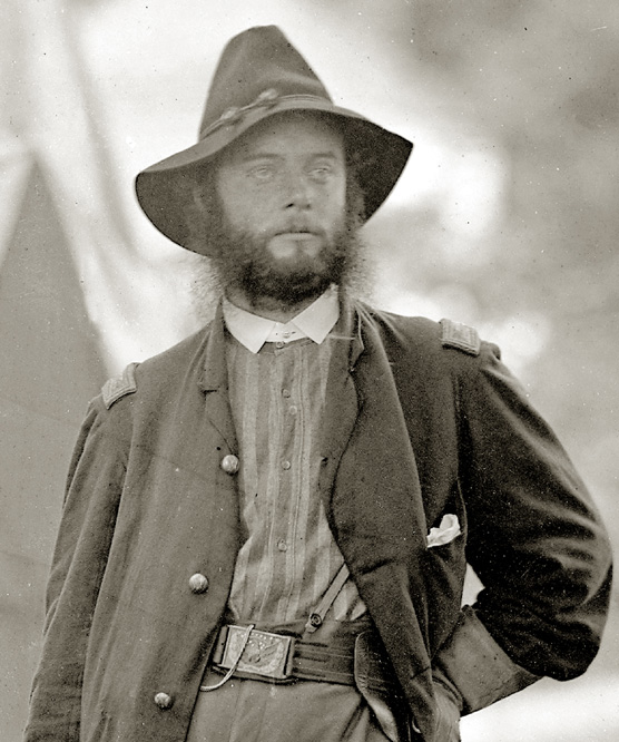 James Harvey Childs was born on the 4th of July, 1834, at Pittsburgh, Pennsylvania. His father was Harvey Childs, a native of Massachusetts. His mother, Jane Bailey (Lowrie) Childs, was a sister of the Hon. Walter H. Lowrie, late Chief Justice of Pennsylvania. He was educated at Miami University, Oxford, Ohio, where he graduated in the class of 1852. He stood six feet tall, was well-proportioned, and enjoyed good health. He was married on the 14th of July, 1857, to Mary H. Howe, eldest daughter of the Hon. Thomas M. Howe, of Pittsburgh.
After graduation, he settled in his home town of Pittsburgh, where he was a civil engineer and a wholesale dry good merchant and manufacturer of cotton goods. He became a prominent and well-respected businessman in the community.
Childs served as first lieutenant of a militia unit, the Pittsburgh City Guards, before the Civil War. When the call was made for troops in that struggle, he promptly tendered his services, and was commissioned first lieutenant of Company K, 12th Pennsylvania Volunteer Infantry. After his short term of service expired, he became active in recruiting the 4th Pennsylvania Cavalry, and was commissioned the new regiment’s first lieutenant colonel on October 18, 1861. On March 12, 1862, before his regiment took the field, he was promoted to colonel when the regiment’s original colonel was transferred to the 5th Pennsylvania Cavalry.
In McClellan’s 1862 Peninsula Campaign, he served with his regiment, the scouting and skirmishing being unusually severe on account of the lack of troops in this arm of the service. His regiment opened the battle at Mechanicsville, during the first of the Seven Days’ engagements, and at Gaines’ Mill and Glendale, was actively employed, proving, in both these desperate encounters what a good regiment he led, as well as the steadfast purpose of its commander.
On evacuating the Peninsula, the regiment moved to Washington, arriving in time to join the Maryland campaign. At Antietam it was attached to Averell’s brigade, and on account of the sickness of General Averell, command of the brigade devolved upon Colonel Childs. The brigade was assigned to the left of the Union line, and after crossing the stone bridge, was posted in support of Clark’s battery, which was heavily engaged. The duty was difficult, and the enemy’s fire proved very destructive. Colonel Childs was upon every part of the field, encouraging his men, and intelligently directing the movements. He had just completed an inspection of the skirmish line and had returned to his headquarters, where he was cheerfully conversing with his staff, when he was struck by a cannonball on the left hip which threw him from his horse, and passed completely through his body.
For a time his mind was clear, and recognizing at once that his wound was mortal, his first concern was for his command. He dispatched Captain Hughes, one of his staff officers, to Brig. Gen. Alfred Pleasanton, commander of the cavalry division assigned to the Army of the Potomac, to apprise him of his fall, and another to his regiment’s second-in-command, Lieutenant Colonel Kerr, to request him to assume command of the brigade. He then sent a message to Dr. Marsh, that, “If he was not
attending to anyone whose life could be saved, to come to him, as he was in great pain.” Finally, he called to his side his Assistant Adjutant-General, Captain Henry King, a townsman, and personal friend, to whom he gave brief messages of affection to his wife and three little children. Of the oldest of the three, a boy bearing the name of his maternal grandfather, as if thinking in his dying moments only of his country for which he had perilled and lost his own life, he said: “Tell Howe to be a good boy, and a good man, and true to his country.” Twenty minutes later, he became delirious, and he died a few minutes later, joining the many other brave men who lost their lives on the bloody battlefield of Antietam. His remains were taken home to Pittsburgh, and were buried in Allegheny Cemetery.
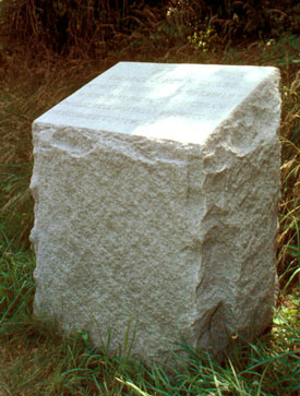 After the war, when the Antietam battlefield was marked, Childs received a monument. Located on Maryland Route 34 near Antietam Creek, the simple stone monument says:
At this spot Colonel James H. Childs of the 4th Pennsylvania Cavalry in temporary command of Averill’s Brigade fell mortally wounded on the morning of Sept. 17, 1862.
Here’s to forgotten cavalryman Col. James H. Childs, who lost his life at Antietam on the Civil War’s bloodiest day.
Scridb filterHat tip to old friend Nick Picerno for passing along this wonderful news.
From a press release issued today by the Shenandoah Valley Battlefields Foundation (of which Nick is a board member):
More Battlefield Land to Be Protected at Third Winchester
SVBF, CWPT, Commonwealth of Virginia Team up to Protect Key ParcelWINCHESTER, Va.—Nestled just north of the bustling Va. Route 7 corridor on the east side of Winchester lie now-quiet farm fields that the National Park Service has described as “some of the most sanguinary fields of the Civil War.†Here, during the Third Battle of Winchester (19 September 1864), on battleground now dubbed the Middle Field, the fighting was close and fierce and the Union’s 19th Corps suffered devastating losses. Forty percent of its men and every one of its regimental commanders was either killed or wounded.
Today, the Shenandoah Valley Battlefields Foundation (SVBF) and the Civil War Preservation Trust (CWPT) joined with the Commonwealth of Virginia to announce that a contract had been signed with the heirs of C.E. Huntsberry to purchase 209 acres of battleground where the 19th Corps and thousands of other Americans on both sides battled one another for control of the northern Valley. SVBF Chairman Irvin Hess signed the contract with the Huntsberry estate last Monday.
Preservation Made Possible Through Partnership
The $3.35 million purchase price will be funded through a partnership between the Battlefields Foundation, the Civil War Preservation Trust, the Commonwealth of Virginia, and private partners.
In late 2005, the Foundation was awarded a $1 million state grant for the project by the Virginia Land Conservation Foundation, a state agency funded by the General Assembly to protect important natural and historic landscapes throughout the Commonwealth.
This fall, the Civil War Preservation Trust agreed to match the state grant with $1.61 million in federal grants and private donations. The Battlefields Foundation has spent $50,000 from its Carrington Williams Preservation Fund toward the final purchase of the property, expected by May 2009. Finalizing the sale is contingent on the Foundation’s ability to raise the remaining $690,000 of the purchase price—the organization has begun a campaign to raise the funds needed to complete the sale and permanently protect the property.
Hess commended the Foundation’s partners for their investment in the project. “This parcel has been a top-priority preservation project since the Battlefields Foundation’s inception,†he said. “But it is only through the efforts of our partners that we have made it this far. We are enormously grateful to the Virginia Land Conservation Foundation and the Civil War Preservation Trust for their tremendous contributions to the protection of this important battlefield landscape.â€
“We now turn to the local community and to Americans everywhere,†Hess continued. “Permanent protection of this hallowed ground will only happen if people in the Shenandoah Valley and beyond step up to the plate and contribute to this cause. We ask you to honor the brave men who fought and lost their lives here, who speak across the generations to us, asking us not to forget what they did here.â€
Connecting Already Preserved Battlefield Areas
The property lies in Frederick County at the heart of the Third Winchester battlefield and links areas previously protected by the Battlefields Foundation and CWPT. Stretching from Interstate 81 at its western end to Millbrook High School to the east, the preserved land will create a 575-acre battlefield preserve that retains much of its historic character—Americans who fought one another on this land almost 150 years ago would recognize its features today. To generate public appreciation of the battle, CWPT in 2007 opened a five-mile walking and biking trail on its 222-acre property. After completing the purchase of the new property, the Battlefields Foundation and the Trust will work together to create a seamless network of interpretive trails throughout this portion of the battlefield. Bordered by growing neighborhoods, the area promises to be an island of quiet green space for generations to come.
â€The Civil War Preservation Trust is proud to partner with the Shenandoah Valley Battlefields Foundation to secure this key acquisition,†remarked Trust President James Lighthizer, noting that the Huntsberry Tract is the largest remaining undisturbed portion of the Third Winchester battlefield. “We have always been keenly aware the battlefield puzzle here was far from complete. Adding the Huntsberry property to already protected land at Third Winchester transforms this historic shrine into a genuine destination for heritage travelers.â€
Lighthizer also reiterated Hess’s call for private donations to make the promise of preserving the Huntsberry tract a reality. “This is not a done deal by a long shot,†stated Lighthizer. “We need all Americans with a passion for history and preservation to rise to the challenge and give generously to this worthwhile effort.â€
Battlefield Preservation an Ongoing and Timely Effort in Virginia
Virginia Governor Timothy M. Kaine emphasized the importance of battlefield preservation to the Commonwealth. “Virginia’s Civil War battlefields are significant threads in our country’s historic fabric. Through the VLCF and the efforts of the Department of Historic Resources, we are preserving Virginia’s important landscapes so that they can continue to educate future generations.â€
Kathleen S. Kilpatrick, Director of the Virginia Department of Historic Resources, agreed. “Time is not on our side in this effort and waiting is not an option,†she said. “If future generations are to learn from these incredible landscapes – places where past generations gave the ultimate sacrifice – we must act now.â€
The core area at Third Winchester covers almost eight square miles, totaling almost 5,000 acres, only 620 of which have been protected so far (not including the Huntsberry property). In the Shenandoah Valley, more than 16,000 acres of core battlefield land are still vulnerable and throughout Virginia and the nation, the numbers are even more dramatic.
Preservation Fulfills Wish of the Property’s Landowner
The Huntsberry family has owned the property since the early settlement of the Shenandoah Valley by Europeans. Originally granted to Huntsberry ancestor Jacob Huntsbarger by Lord Fairfax in 1762, the land has played a significant role in the agricultural history of Frederick County. In addition, the Huntsberry house itself, the remains of which still exist today, is noted on Civil War-era maps of the battlefield.
“I remember summers here when I was a boy,†said Bob Huntsberry, the great-grandson of the late C.E. Huntsberry and co-manager of his estate. “My grandmother kept us busy—we fed the pigs and collected the eggs and collected dandelions and had a lot of fun. This is an important place for my family—and growing up, we knew that it was historically important, too. We felt pretty strongly that it needed to be preserved so we are very happy that it will end up in good hands and that people will someday be able to come and learn about what happened here.â€
Third Battle of Winchester
The property is in the core area of the Third Winchester (Opequon) battlefield where more than 54,000 Americans fought one another in the opening salvo of Union Gen. Philip Sheridan’s devastating Shenandoah Campaign – a military operation that ultimately decimated the Valley’s agricultural bounty in weeks of burning and destruction stretching as far south as Staunton.
In the early morning hours of September 19, 1864, Sheridan’s troops marched west from encampments around Berryville, ultimately stacking up in the Berryville Canyon along the modern-day alignment of eastbound Va. Route 7. The traffic jam created by slow-moving supply wagons delayed the deployment of the Federal army east of Winchester and foiled Sheridan’s plan to surprise and wrest the city from Gen. Jubal Early’s Confederates.
As Early moved troops south from Stephenson’s Depot to meet the Union attack, Sheridan sent portions of his army north of the Berryville Pike (Va. Route 7) to confront the southerners’ movement. The ensuing fighting at First Woods, Middle Field, and Second Woods along Redbud Run – including the Huntsberry property – was fierce, close, and devastating. Nearly 1,500 men were killed or wounded in this area of the battlefield alone and one soldier remembered the area as “that basin of Hell.â€
In the 1992 National Park Service Study of Civil War Sites in the Shenandoah Valley, historian David W. Lowe wrote, “Third Winchester was the largest and most desperately contested battle of the Civil War in the Shenandoah Valley, resulting in more than 9,000 casualties. The Union 19th Corps sustained 40 percent casualties (2,074 men) and lost every regimental commander during its assaults on the Middle Field and Second Woods…The Middle Field ranks with some of the most sanguinary fields of the Civil War, witnessing more than 3,000 casualties.â€
In addition, it was by traversing these fields that two men who would serve their country in this battle would, through destiny, continue to serve the nation as President of the United States: Rutherford B. Hayes and William McKinley.
Protection of Natural Areas and Archeological Resources
The property contains almost a half-mile of Redbud Run, a major tributary of Opequon Creek, which drains into the Potomac River. Preservation of this area protects the stream’s sloped and forested buffer, which will enhance water quality for the stream itself as well as the downstream watersheds, including the Chesapeake Bay.
Once the purchase is finalized, portions of the property will remain in agricultural use while the Battlefields Foundation conducts archeological and cultural resources studies to learn more about the history that the land holds. This research will aid the Foundation as it works with its partners to determine appropriate types and locations of future interpretive activities.
This is fabulous news, and real accomplishment for all involved. It’s a very important parcel for the interpretation and preservation of the Third Winchester battlefield, and I am just tickled that it’s going to be forever preserved in its largely pristine condition. This now means that a major portion of the Third Winchester battlefield is forever preserved, and that these portions of the battlefield will be readily accessible to the public. Kudos to all concerned for a job very well done.
Please find a few dollars to contribute toward this very worthy cause.
The contrast of this wonderful preservation news against the horrific abandonment of their historic duty by the Cedar Creek Battlefield Foundation is just shocking to me…..
Scridb filterAlthough Kevin Levin disagrees with me, I remain convinced that there is something inherently inappropriate and a conflict of interest in the hiring of John Latschar to become the new head of the Gettysburg Foundation.
From Saturday’s edition of The Gettysburg Times:
What will be Latschar’s legacy?
Published: Saturday, November 8, 2008 1:44 PM EST
BY SCOT ANDREW PITZERTimes Staff Writer
Love him or hate him, one thing about John Latschar’s tenure as superintendent at Gettysburg National Military Park is certain — he will be remembered.
“My legacy is up for other people to decide,†Latschar said Friday, the day he announced he was leaving his post after 14 years on the job.
Latschar came to town in the mid-1990s with a vision: to restore the 6,000 acre battlefield to the way it looked in 1863, when the Battle of Gettysburg was fought here.
Some of the ideas — like white tail deer management, one way roads, and tree removal — seemed bogus at the time.
Other proposals, such as the $103 million Battlefield Visitor Center along the Baltimore Pike, have just come to fruition.
“When he came, the fireworks started,†said Gettysburg Borough Council President Dick Peterson, who was a Steinwehr Avenue businessman at the time. “But in a peculiar way, it brought the community together.â€
Latschar announced Friday that he’s resigning effective March 1, 2009, to take over as president of the Gettysburg Foundation, the park’s non-profit fundraising partner. Acting foundation President Robert C. Wilburn is resigning at the same time, and plans to pursue other career options.
“One word describes Dr. Latschar when I think of his attributes: brilliant,†said Main Street Board of Directors Chairman Bill Kough. “His priorities are family, country, history and community.â€
The battlefield boss has developed a legion of critics over the years.
“It’s not unexpected that he’s going over to the foundation,†said Steinwehr Avenue entrepreneur Eric Uberman. “He’s never going to leave.â€
Some long-time opponents of the Latschar regime are questioning the legalities of his career move.
“It’s a blatant conflict of interests. I’m just flabbergasted that he’s trying to do this,†said Franklin Silbey, an historic preservationist. “He presided over the creation of the General Management Plan, he presided over the supposed competitive bidding process for the visitor center, he presided over the creation of the Gettysburg Foundation, and he presided over the project. Now he’s going to work for the company that he created, for triple the amount of money that he’s making now.â€
Under Latschar’s watch, the park adopted a General Management Plan in 1999, which laid out a long-term vision for the battlefield. The plan’s primary project, a new battlefield visitor center, generated immediate controversy.
“We started at arms length, the first time we had any interaction with him,†said Gettysburg Borough Councilman Ted Streeter, a veteran board member. “But honestly, we gained a lot of respect for each other over the years.â€
Borough Council Vice President Holliday Giles spoke highly of the man who she feels was instrumental in several downtown restoration projects, including the Gettysburg Railroad Station and David Wills House.
“Whatever project John Latschar takes on, especially with the Borough of Gettysburg, it is very apparent that he uses all of his expertise and knowledge for all to benefit,†Giles said Friday.
Peterson was one of Latschar’s most vocal adversaries in the 1990s, when the park first announced plans to relocate the visitor center from the Steinwehr Avenue business corridor to the Baltimore Pike. Now, he considers Latschar a friend.
“He’s taken a lot of criticism over the years and he’s survived,†said Peterson. “He’s changed and we’ve changed. Twenty years from now, we won’t even remember all of the controversy. We’ll remember John for his vision and what was accomplished here.â€
Latschar may have been an intimidating figure over the years, but local leaders maintain that he’s generally been very approachable.
“We were always able to sit down and come to a mutual understanding that was beneficial and positive to our township,†said Cumberland Township Board of Supervisors Chairman John P. Gregor.
Latschar has been superintendent of the park since 1994, and is a 31-year veteran of the National Park Service. He previously served as the first Superintendent of Steamtown National Historic Site in Scranton, Pa., and in various capacities at the park’s Denver Service Center. Latschar was named Superintendent of the Year for the Northeast Region in 1991 and in 2001.
In my mind, the quote from Franklin Silbey says all that needs to be said.
Personally, I’m glad I was never fleeced into donating a dime for Latschar’s Folly, aka the new Visitor’s Center. Now, I’m REALLY glad I didn’t do so.
Sorry, Kevin, but I vigorously disagree with you on this one.
Scridb filterSponsors


 Blogs I like
- Andrew Duppstadt
- Andy Etman
- Blue Gray Daily
- Bob O'Neill
- Bottle Rocket Science
- Brooks Simpson
- Bruce Long
- Charlie Knight
- Civil Warriors
- Corey Meyer
- Craig Swain
- Damien Shiels
- Dave Powell
- David Woodbury
- Dimitri Rotov
- Drew Wagenhoffer
- Emerging Civil War Historians
- Harry Smeltzer
- J. D. Petruzzi
- Jack Dempsey
- Jim Miller
- Jim Rosebrock
- Jim Schmidt
- John Hoptak
- Kevin Levin
- Kraig McNutt
- Lee Hutch
- Mannie Gentile
- Mark Grimsley
- Matt Lively
- Michael Aubrecht
- Michael C. Hardy
- Michael Lynch
- Mike Block
- Mike Noirot
- Mysteries and Conundrums
- Rea Andrew Redd
- Richard J. Bell
- Richard McCormick
- Robert H. Moore, II
- Robert Redd
- Scott Mingus
- Scott Patchan
- Sean Heuvel
- Steve Light
- Susan Wittenberg
- Ted Savas
- TOCWOC
- Tom Clemens
- You Stink! blog
- Civil War Sites
- Central Ohio Civil War Roundtable
- Civil War Trust
- CWDG Online
- Dennis Morris
- J. David Petruzzi
- Ohio Civil War 150
- Ohio in the Civil War
- One Continuous Fight: The Retreat from Gettysburg and the Pursuit of Lee’s Army of Northern Virginia, July 4-14, 1863
- Pennsylvania in the Civil War
- Plenty of Blame to Go Around: Jeb Stuart’s Controversial Ride to Gettysburg
- Randy Drais
- Rush’s Lancers, also known as the Sixth Pennsylvania Cavalry
- The Books of Eric J. Wittenberg
- Wade Sokolosky
- West Virginia in the Civil War
- Woodbury Historical Tours
- Compilation Blogs
- Other Sites
- Our sponsors
- Publishers of Civil War History
- Popular Pages
- Archives